Put this hike on your list to do! This trail is very popular but worth fighting the crowds to see. Fortunately you can beat most of the crowd by arriving early to the trailhead, which is highly recommend as the parking area will fill up fast after 10:00 a.m. on a weekend. Speaking of parking, as of 2012, the cost to park at the trailhead is $9.00. The only way around this fee is to buy a
Red Rock Pass from various Ranger Stations in the area for $5.00 and park on the main road of Oak Creek Canyon. The trail is located in the beautiful and popular Oak Creek Canyon near Sedona. See directions at the end of this narrative.
 |
| "Official" end of the trail at 3 miles |
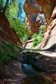
This trail is an out and back. Although there is the option of backpacking the entire 14 mile length; one which I hope to accomplish in the future. The "official" trail ends at 3 miles, your turnaround point. You will know you have reached this spot as the trail ends and further progress requires the hiker to walk in the creek. The turnaround point is a beautiful spot where the creek has carved out a small tunnelish area, (is that a word).


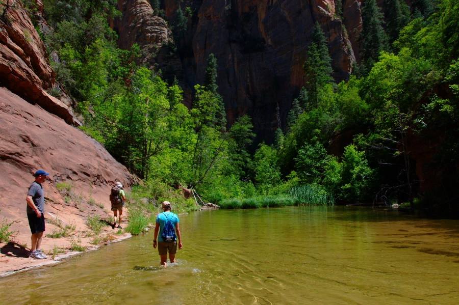
The trail starts by crossing over Oak Creek via a large bridge and then turns to your left through an old apple orchard. You then will come to an old homestead area with an interesting cabin. The trail then turns right into the "Secret Mountain Wilderness." This trail has several creek crossings. Although on the official section of the trail you can manage to keep your feet dry by rock hopping across the small crossings. This trail is simply put, beautiful. The trail is extremely vegetated and its hard to believe you are in Arizona with how green and lush the area is. Sandstone canyon walls tower high above, small waterfalls and inviting pools line this trail. The trail stays pretty much right next to the creek the entire time. The only exception is near the end at about 2.7 miles where you will climb a short but fairly steep hill onto a small ridge, you quickly descend back down and follow the trail another hundred yards. The official trail ends at this location, where the canyon suddenly narrows and forms a tunnel like area.
 |
| 3 mile point |
|

The day I hiked this trail, in June, there were hundreds of butterflies. It was incredible. There is also poison ivy along this trail, so be careful if you leave the main trail for any reason. Also, we were able to filter the water and drink with no problems.
The group I hiked with entered the creek at the 3 mile mark and we continued upward about another 1.5 miles. This required us to be in the creek about 60% of the time. The other 40% was bushwhacking through a lot of overgrown vegetation. There is no official trail to follow, although you can see some areas that have been stamped down a bit. If you have the time and don't mind getting wet it is worth the extra time to explore up the canyon. The canyon narrows and about 3.75 miles in is a large pool. The pool is shallow but the beauty of the spot is incomparable. Further up at about 4.5 miles we found a pool large enough to swim in. This is the point our group turned around and began the hike out.
This hike is easy and flat, all but the small hill toward the end. On our hike out in the afternoon the trail was very busy. We began our hike at 9:00 and returned to the trailhead at 3:00.
The following photos are all past the 3 mile turnaround point.
 |
| Just past tunnel area at 3.1 miles |
 |
| Large pool. 3.75 miles in |
|
 |
| Backpackers heading down West Fork |
Length: 6 miles out and back (official trail)
Elevation Gain: 200 feet
Difficulty: Easy to 3 mile point. Past 3 miles requires walking in water, scrambling over boulders and bush whacking- that's where it gets fun.
Recommened: All hiking levels to 3 mile point
Season: Spring, Summer, Fall
Hiking Time: 2 hours to 3 mile mark. Plan on extra time to explore and play in the water
Directions: From Phoenix take Interstate 17 North, Exit 298, just north of Camp Verde to State Route 179 North, turn left. Drive through Sedona to the "Y" junction with Highway 89A. (large roundabout) Turn right onto 89A, cross the large bridge over Oak Creek that enters the canyon. Drive 9 miles and watch for the sign for the Westfork trailhead, the trailhead and parking are on your left. The parking area is called "Call of the Canyon".


 While this spot is not a hiking location, it is a great destination and one not to miss. Red Rock Crossing is located 7 miles southwest of Sedona, and unfortunately you will not be alone when you visit. In fact while we were there several tour buses unloaded to enjoy the view. However, it is still worth your time to visit. Try to go early or during the week. Red Rock Crossing is operated by a private concessionaire on Federal Land. The entrance fee is $9.00 a car (up to five in a car). Yes, it is a tad pricey! You may visit from 9:00 a.m. until dark. There are several picnic tables and a nice path that will take you to various parts of the creek. Take your time to explore the path network and play in the water.
 One spot not to miss is called Buddah Bay, this is a location that some people believe is an energy vortex. Regardless of your beliefs people have built up small rock monuments, like cairns along the path. It is actually quite the sight and fun to build a few with your kids.