Showing posts with label Usery Mountain Park. Show all posts

Sunday, April 28, 2013

Spillway Trail to Blevins Loop- Usery Mountain Park- Mountain Biking

If you need a good place to ride untechnical (beginner) single track then Usery Mountain Park in Mesa is a great spot to go.    There are so many options to ride this trail system with most of the trails joining up to allow for more miles and ride time.  I choose to start my ride on the Spillway trail which I accessed off of Signal Butte Road. Directions at the end of this post.  Or see my trail map created in Every Trail below.  This eliminated the need to pay an entrance fee into Usery Mountain Park. The first mile of the trail is on the Spillway trail.  It connects to the Blevins Loop trail which I rode in a counter clockwise direction.  You can travel the loop trail in either direction as it is relatively flat, besides the several arroyo crossings which add a little bit to the trail in regards to shifting and few spots to catch a little bit of air.  The route I took made for a 6 mile ride. 

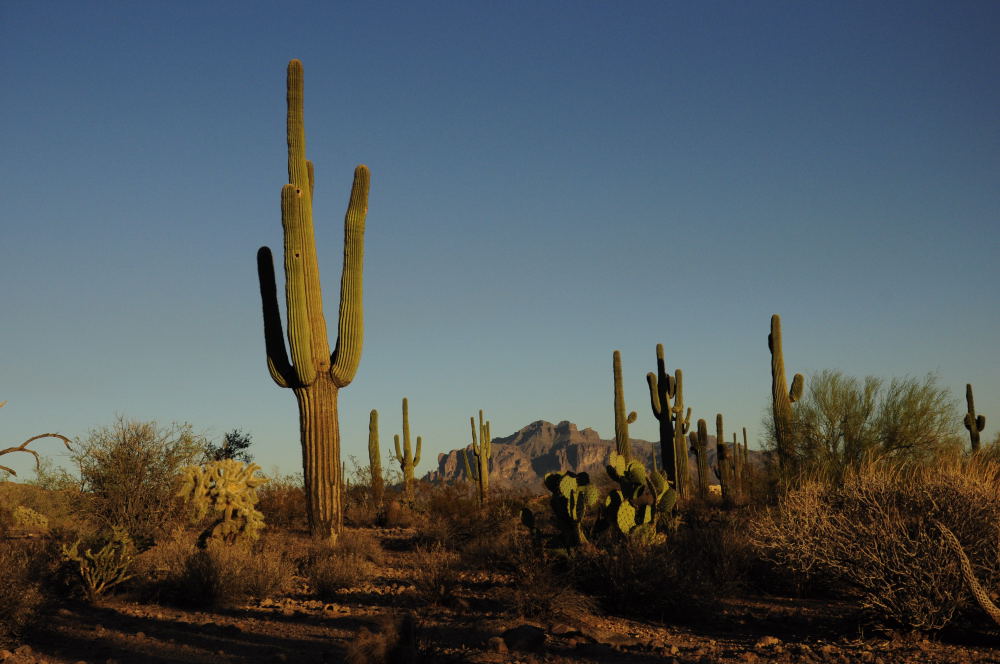
This really is a pretty trail with all the cactus and especially saguaros that line the trail.  Obviously you have to be careful not to end up in one of those cactus, especially the cholla- OUCH!  This would also make a great trail to run or hike in the evening or cool mornings.

Start at the access gate into Usery Mountain Park on Signal Butte and E. Jensen Road.  The Spillway trail will head east toward the Superstitions Mountains for about 200 yards.  You will then come to a "T".  Turn north (left).  Follow to a canal.  When you are on top of the canal take the trail that heads across the dry canal to the northeast.  Follow this for about 1/4 mile and you will come to another intersection with the Ruidoso Trail.  Turn left staying on the Spillway trail which continues to head north.  Another 1/4 mile you will come to the intersection with the Meridian Trail. Turn left and follow for about 200 yards where you will come to a fork in the trail which is the Blevins Loop.  I turned right, riding the trail counterclockwise.  About 2 miles into the Blevins Loop either direction you will come to a trail called the Moon Rock Trail.  I took this trail which added an extra 1.4 miles to the route.  It links back up with the Blevins trail.  Continue on the Blevins Trail until you are back at the Merdian Trail where you will retrace your ride back to your car.  Enjoy!

Below is a link to the route I took on my ride.
Spillway and Blevins Loop

EveryTrail - Find the best Hiking near Mesa, Arizona

Like I said prior, there are so many different options you could add to this trail. Click HERE for a link to the Usery Mountain Park Map which shows all the trails in the area.

Length:  6 miles
Difficulty: Easy/Beginner
Elevation Gain: unknown but minimal
Trail Type: Single Track- Loop with 1 mile trail to access loop.
Directions:  Exit on Signal Butte from US60.  Head North.  Continue heading North through Brown approximately 1 more mile you will see E Jensen Road on your left. Look to your right and you will find a pull out and access gate to the Spillway Trail.


Saturday, November 5, 2011

Cat Peak Loop - Usery Mountain Park.


 After work this week I felt like a nice hike to get out and enjoy the amazing fall weather in Arizona. I headed up to one of my favorite trailheads and one I really don't think people know that much about. The trailhead is at the North end of Meridian Road in East Mesa. The trail head allows access into the Tonto National Forest and links up with the Pass Mountain Trail, which also cuts through Usery Mountain Park. The great thing about this trailhead, you can access the Pass Mountain trail and other Usery Mountain Park trails such as Cat Peak without paying the entrance fee. 'Nuff said.

Cat Peak
To locate the trailhead; exit the US 60 on Ellsworth road and drive north. Turn right on Southern and then left on Meridian. Follow to the end of the road. You can't miss it as you will run right into it. To hike the Cat Peak Loop you must find the Pass Mountain Trail and head south. This can be a tad tricky if you are not paying attention. There are several spur trails leading off in the area. Upon leaving your car cross into the Tonto National Forest Boundaries through the access gate. Follow the well worn trail to your left. You will wind about 200 yards and come to a 4 way split in the trail. Take the trail straight ahead of you marked by a large cairn. You will then come to the edge of a ravine. The trail goes left here or straight down the ravine. Follow the trail into the ravine and up the other side. You will then come to another fork. This is the Pass Mountain Loop trail. For this hike to Cats Peak take the trail to your left. The trail winds around the to the south of the Pass Mountains. The trail is lined with saguaros and other cactus. I would suggest hiking this trail in the evening as the colors in the cactus come alive in the evening sky. The trail is pretty easy and dips in and out of a few drainage's. This is a great hike to take your kids on or family from out of town to show them the area.


Cholla Forest
After hiking about 1.5 miles you will come to another fork that is marked with a sign for Cat Peak Trail. Follow the trail through the gate entrance to your left. Cat Peak is a loop around two peaks. I opted to head to my right. One interesting section is just after you round the first turn in the hill and near the back side. There is a large Cholla "forest" that the trail cuts right through. This would be a great place for low light photography. The trail then curves around to the back of the peak and you come to another sign marking the trails intersection with The Blevin's Trail. Follow the sign to your left and continue with the loop. 
View from Cat's Peak Pass

A few hundred more yards and you come to another sign. You can go straight and keep heading on the main loop or head to your left following the Cat Peak Pass Trail. I opted for this route, hoping the trail would take me to the top of the peak. I was wrong. The trail climbs just a bit and then heads down again linking back up with the loop trail. One nice advantage to this option is you get a nice view of the Superstition Mountains as you crest the small hill. Follow the trail to the right and you will soon be back where you started at the Cat Peak Loop starting point. Head back to your right along the Pass Mountain Trail to the trail head.

There is nothing to grand on this hike, but it is a great evening hike to enjoy the cactus and the views of the Superstition Mountains.  


Hike Details:
Length:  4 miles 
Elevation Gain: 160 feet
Difficulty:  Easy
Kids:  All ages recommended
Hiking Time:  1-2 hours
Fee:  None if accessed off Meridian Road.   

Saturday, November 7, 2009

Pass Mountain Trail- Usery Mountain Park, Mesa

Pass mountain trail head is located in Usery Mountain Park in Mesa. This is a loop trail and is 7.4 miles long. This is a great loop trail, with beautiful views from the North Side of the rugged country below 4 Peaks. I gained access to this trail via Meridian Rd, which allows access to Tonto National Forest without paying the entrance fee at Usery Park. The majority of the trail lies in National Forest boundaries. Upon arriving at the trail head I spoke with a few hikers about the trail. The consensus is the best part of the trail is the view off the north side of the mountain. At this trailhead if you choose to follow the trail to the North, you will encounter a steep climb early on into your hike. I chose to hike the trail counter-clockwise so I could head up the hill and get my lungs pumping a bit. As you leave the parking area follow the well worn trail for a few 100 yards you will come to a cross section in the trail. DO NOT GO left or right but find the cairn directly in front of you and cross through the wash to the other side. This will take you to the actual Pass Mountain Trail. Upon reaching the next intersection I hiked to the right, heading towards the large cliff in front of you. Going this way you will have to hike up a 500 foot elevation gain right off the bat to the saddle, but this is the hardest part of the trail and is quickly over. It also guarantees an elevated heart rate. Once upon the saddle the trail winds around the side of the mountain to the west. This is a well traveled and maintained trail. It is busy on the weekends with hikers, joggers, bikers and horse back riders. Enjoy the sweeping view of the country to your north. You will round the mountain and begin heading south and catch a view of Fountain Hills, and the sprawling metro city below. Keep on the main trail and avoid following several spur trails that branch off periodically. The trail takes you to Usery park and to the Wind Cave Trail head. Keep heading east through the park. Once on this south side the Saguaros are more prominent along with all the other familiar cactus in the area. Keep an eye out of cholla on the trail. This is a great loop hike and I completed it in 2 hours 45 minutes. I did not stop for many breaks during the hike. It is not difficult, but is long so plan accordingly.

Length: 7.4 miles- loop trail
Elevation Gain: ?
Kids:
7.4 miles is a bit long for kids to enjoy the hike
Hiking Time:
3 hours
Fee:
Free off Meridian Rd, 6$ in Usery Mountain Park
Guides:
60 Hikes within 60 Miles of Phoenix
Directions: US 60 East to Ironwood Rd. North on Ironwood Rd. Left on McKellip Rd. Right on Meridian Rd. Follow to the end of the road and park in trailhead.