Showing posts with label Rim Country Trails. Show all posts

Wednesday, July 4, 2012

Horton Creek

This is a great hike east of Payson just below the Mogollon Rim.  The trail is easy to follow, fairly flat except for a gradual hill towards the turn around point of the hike and follows a beautiful creek known as Horton Creek.  The trail is out and back, with the trail leading to the head of Horton Creek where the spring literally comes right out of the side of the mountain.  The spring is 3.3 miles from the trailhead.  This is a great hike to do on a hot summer day as the trail stays within 200 yards of the creek the entire trail, except the hill at the end of the hike.  There are large trees providing shade the majority of the hike. 

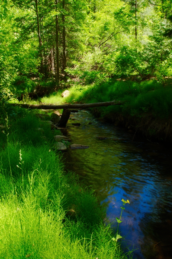
The trail is located 15 miles east of Payson on Hwy 260.  Turn left on Tonto Creek Road (FR 289) and drive 1 mile to the upper Tonto Campground.  Do not stop at the first campground on your left.  Keep driving to the second campground on your right.  Pass the entrance to the campground, cross a cement bridge and park on your left in the signed parking area.  The trail begins back across the bridge and up the road toward the campground.  You will see signs directing you to the trail.

The trail starts by dropping you down into a dry creek bed.  Follow the trail for half a mile next to the the dry creek bed.  Don't worry you will come to the water soon.  The trail will follow next to the creek for the most part.  A few spur trails will branch of to your right heading down to the creek.  These are worth taking as several spots on the creek are incredibly beautiful.  Beautiful lush green trees, yellow flowers and small water falls make this area a little paradise. 

The trail continues up towards the rim with the last mile consisting of a gradual hill switch backing its way up the base of the rim.  This is not a difficult hill and can be managed by most people, including young children.  At  the top of the hill the trail intersects with the Highline Trail.  Turn right and follow the trail for about 200 yards to the Spring.  This is a great spot and several people had backpacked and were camping in the area.  Once you reach the Spring this is your turnaround point and it's an easy hike back down the trail to your car.

I would recommend this hike to any hiking level.  Small children will enjoy playing in the water, as will adults such as myself.  The trail was fairly busy the day I hiked it on a Saturday.  But not overly crowded.  Definitely put this on your list of hikes to do in Rim Country.

Length:  6. 6 miles out and back
Elevation Gain: 1,183 feet
Difficulty: Easy- Recommended for families with small children
Season: Spring, Summer, Fall
Hiking Time: 3-4 hours with a lot of time used to enjoy the creek and the spring at the end of the trail.
Directions:  See narrative- passenger car


Saturday, January 29, 2011

Tonto Natural Bridge, Payson Arizona

View into the Bridge
  

Under the Bridge
I've been up to Tonto Natural Bridge a few times since moving to Arizona and I have to say it is worth the drive from the valley. Unfortunately this State park is on the Arizona budget hit list, but that is another conversation entirely.  Check the website for information on park hours Lets hope that we don't lose access to this amazing spot. Tonto Natural Bridge is located Northwest of Payson, Arizona.  It is the world's largest known travertine natural bridge. The bridge, which looks more like a tunnel, is 150 feet wide and 183 feet high. Four hiking trails descend down to the bridge.  Click here for a link to a map of the trails in the park  My prefered hike is to hike down the "Gowan Trail, which leads you to the canyon floor and the opening of the bridge.  You can then hike under the bridge, which is akin to hiking through a tunnel.  It is 400 feet long and requires a bit of scrambling and steady feet.  Not recommended for anyone afraid of exposed edges.  If you don't feel up to scrambling through the tunnel you can enjoy the water fall coming off the top of the bridge and the pools waiting to be explored.  Once you are through the bridge continue to follow the trail up the canyon as it winds away long the creek.  This is a beauitful spot, with an incredible amount of vegetation.  Small waterfalls trickle down the side of the canyon in various spots.  The trail will wind up out of the canyon and you will end up on top at the Pine Canyon Trailhead.  The trail is only 1 mile in length and is a loop trail.  However, you can spend an entire day in the canyon exploring and playing in the pools. Driving Directions from Phoenix 
North on AZ 87 to Payson
Continue through Payson on AZ 87
Head 9 Miles and you see a road on your Left Marked Tonto Natural Bridge, follow this road to the park.

Kids working their way under the bridge

Saturday, October 16, 2010

Ellison Cascades


This is a short hike to a great swimming hole with a water fall.  The area is north of Payson and gets a lot of use.  Unfortunately a few years back someone decided not to put their campfire out and the area to the southwest was burned out.  There are two ways to access this waterfall.  I have included a map showing both routes.  The easiest way is by walking down an old jeep road.   The hike is an easy 1 mile with a gradual hill.  People of all ages and skill level will be able to get to this swimming hole by this route, which is why it is so popular.  You can easily spend an entire day at this spot enjoying the water fall, the swimming hole, catching frogs, and exploring the area to the southwest, which is the aforementioned  water wheel area, where several creeks meet and converge into one drainage.  It is an impressive site.


Water Wheel and Ellison Cascades


EveryTrail - Find the best Hiking in Arizona
  EASY ROUTE
This hike is located outside of Payson, Arizona.  Follow Hwy 87 thru Payson.  Just after the roundabout you will see a road on your right called Houston Mesa.  Follow this road 8.2 miles to FR 420.  At mile 7 you will pass the Water Wheel parking area, to access the easy route continue 1.2 more miles to FR 420.  There is a small turnout on your right with a trail head sign.  The sign informs you not to park here.  We parked about 50 yards further up on another turnout and walked back down.  Follow the old jeep road thru the gate.  The road will gradually descend.  Once you reach the bottom of the hill you will see a trail go off to your right thru the trees, you can take this and follow it to an area below the falls where the creek is.  Ellison cascades is to your left, Water Wheel is to your right.  To find the water wheel area just follow the creek till you come to the confluence of creeks, you can't miss it.  It is probably about 1/4 mile down.  To go to Ellison Cascades follow the creek up to your left.  You will see the cascades in the distance.

You can also, access the cascades by continuing to follow the jeep trail instead of taking the spur trail.  The road will climb up a hill and you will shortly see the cascades or rather hear them on your right.  Find a way down to the creek through the rocks.  If you reach a fence saying private property you have gone too far.  All said the cascades are only about .9 miles from the trail head.  Remember to bring swimming clothes, camera and be ready for a nice day in the water.

Water Wheel
ROUTE TWO FROM WATER WHEEL PARKING AREA
The Second option and a bit more scenic and involves one creek crossing and scrambling up rock is the Water Wheel parking area at mile marker 7..  This is a fee area, and costs $6.00 to park. The trail begins at the far left end of the parking area as you pull in.  Follow the trail as it heads along the creek.  You will come to an area where it becomes rocky gradually heads up over the rocky slab.  This is an easy trail to find, but if you are not much of a hiker I would recommend the first route I described.  Continue to the follow the trail as it climbs up above the creek.  You will see the creek below rushing through a narrow gap, with a waterfall.  It is a great spot.  The trail descends back down the rock outcropping, at this point two creeks come together to form what is called The Water Wheel.  Find a safe spot to cross the creek and follow the creek coming from your right.  Continue to follow the creek as it winds its way up.  The creek disappears at one point but keep an eye out for the path and as long as you stay in the creek bed area you are fine.  You will eventually meet back up with the water and a large rocky creek bed area.  You will see the cascades at the far end of this area.   Please consult the map I have attached that indicates both routes.

Sunday, August 9, 2009

Fossil Springs


Fossil Springs is one of the best places I have hiked since moving to Arizona 6 years ago. The reason it is literally an oasis tucked away in canyon. The hike begins near Strawberry, Arizona at the base of the Mogollon Rim. The trail starts at the top and descends just under 4 miles into a canyon. This area is wilderness and the trail is an old road used to access the dam in the canyon. The descent is gradual but remember 4 miles down means 4 miles back up and out at the end of the day. You can see the trail winding its way down into the canyon as you hike along. It took us about 1 3/4 hours to hike down and that was at a slow pace.

Once you reach the bottom of the canyon, you will come to a fork. Take the trail to the left to Fossil Springs Dam. You will soon come to a dry creek bed which we mistook for Fossil Springs, do not let this fool you, continue along the trail and cross over the creek bed. Approximately 100 yards later you will find yourself in a thick vegetated area. The trail will fork again to your left- which appears as a side trail. Take this fork and it will lead you to the hidden oasis of Fossil Springs. You will cross over the spring where it bubbles up and out of the ground. We actually filled our water bottles with this fresh water before our hike out.

The natural spring produces an amazing amount of water and forms swimming holes and waterfalls. Rope swings have been attached inviting you to jump into the water and cool off from your hike down. Once you've enjoyed this swimming hole head further down the trail about 1/4 of a mile and you will come to the Fossil Creek Dam. (This is currently being taken down as of 2009). A nice flowing waterfall forms here, and their are alcoves which have been cut out by the water you can swim into. The water here is amazingly clear blue. Rope swings are also at this location.

Plan on spending the majority of your time enjoying this little oasis. Many people backpack down and spend the night. Remember the hike out is long, up hill the entire way, and exposed to the sun pretty much at all times. WATER, WATER, WATER is a must have for this hike!!!!!! Oh and bug spray!!!


Length: 7.75 mile round trip
Elevation Change: 1280 feet
Difficulty: Moderate- the hike is not difficult but long and exposed
Hiking Time: Full day
Directions from Phoenix:
Hwy 87 North towards Payson. Drive thru Payson to Strawberry. At Strawberry take a left on Fossil Creek Road. Stay on it for about 5 miles. The first 2 miles is paved, the next 3 miles will be on a well-maintained dirt road that any car can drive on. After about 5 miles you'll see a turnoff that leads to a parking lot on the right side.
Trail Information: RANGER DISTRICT
Payson Ranger Station
1009 East Highway 260
Payson, Arizona 85541
Phone (928) 474-7900
Fax (928) 474-7999