Showing posts with label Water. Show all posts

Sunday, February 9, 2014

Boulder Canyon Loop

Trailhead
This is a fantastic hike!!!  It has plenty of expansive views, tall canyon walls, pools of water and includes a small section of bushwhacking and boulder navigation to make it a little more fun and exciting.  The trail starts at the Canyon Lake trail head in the Superstition Mountains and is located directly across the street from the parking lot of the Canyon Lake Marina.  Park in the parking area of Canyon Lake Marina closest to the road on the south end of the lot.  It is signed for trail head parking only.  Walk across the road and start hiking up Trail #103, Boulder Canyon Trail. 

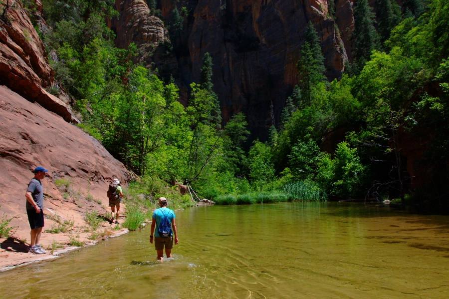
The trail starts out on a steady climb for the first mile, once you top out on the ridge make sure you take a look behind you at Canyon Lake below.  You get an amazing view of the beautiful desert lake.  Continue on the trail and you will soon come to an expansive view into the Superstition Wilderness and of Weavers Needle and Battleship Mountain in the distance.  The trail winds its away along the ridge and then along the hill side.  Around mile 2 you will begin a steady descent into LaBarge Canyon which you can see below on your right. At about mile 3 you will reach LaBarge Creek.  The main trail continues across the creek, but to complete this described hike you will leave the main trail and turn right (Northwest) and follow the creek bed as it winds back towards Canyon Lake.  You will stay in the creek bed for the next 1.5 miles or thereabouts. Warning, this section of the hike may be impassible after heavy rains.


This section of the hike is where it gets fun.  The canyon walls begin to get higher and the canyon begins to narrow as you make your way down the creek bed.  At about mile 3.5 (sorry I don't have exact location) you will come to a section where the canyon floor is overgrown in brush. You will need to just bush whack your way through this, there is no wrong way to go, just keep heading down the creek bed.  At this spot we started noticing small pools of water as well.  After you break through the tangeled mess you will come to a bend in the canyon and also a fork.  Boulder Canyon is the canyon you will see coming in off of your left.
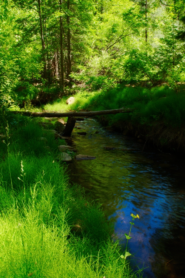
The canyon walls here are quite impressive.  Keep your eyes out for big horn sheep while in this canyon as well.  Soon after Boulder Canyon comes in you will come to a section with a few large boulders and a large pool of water.  To pass this spot keep to the right side of the canyon.  There are a few options on that side to get around the pool of water.

Exit Location
Continue down the canyon and it will open wide again, with several pools along the way.  You will come to one other nice sections where the canyon narrows for about 100 yards and the floor is littered with colorful rocks.  After you pass this spot the canyon will again open wide.  Continue down.  At about mile 5.0 you will come to left bend in the canyon and a large pool of water at the end.  This is actually the inlet of Canyon Lake.  Directly in front of you as the canyon bends to your left is a slopping rock hill.  This is your exit point.  You will also see a few cairns dotting their way up the side of the hill.  Once on top, you will see the inlet of Canyon Lake below.  Follow the trail as it continues up the hill.  There are quite a few trails that meander through here, but just keep left turns and you will link back into the main trail that you came in on.

Follow this link for the mapped route of the trail. 

In all this trail is about 5.5 miles, depending on the route you take through the canyon floor.  I would rate this moderate.  It is a fun trail that gives you a taste of everything in a short 5 miles. 

Length: 5.5 miles
Overall Elevation Accumulation: 2, 103 feet
Difficulty:  Moderate
Traffic:  Moderate on Trail #103, Light in the canyon
Fee:  No fee!
Waters and Restrooms at Canyon Lake Marina


Kid Friendly
Hike Time:  3 hours
Directions From Phoenix:  East on US 60; exit north on Idaho Road; turn right on Hwy 88 (The Apache Trail) Drive 15 miles to the Canyon Lake Marina.  The Marina is right after the second bridge crossing.  Turn left into the marina and park on south side of lot closest to the highway. 

View back up the canyon from the exit point

Sunday, October 13, 2013

Red Rock Crossing/Crescent Moon Picnic Area - Sedona

Chances are if you have seen a photo of Sedona, then you have viewed this photo from Red Rock Crossing of Oak Creek flowing below Cathedral Rock. 
While this spot is not a hiking location, it is a great destination and one not to miss.  Red Rock Crossing is located 7 miles southwest of Sedona, and unfortunately you will not be alone when you visit.  In fact while we were there several tour buses unloaded to enjoy the view. However, it is still worth your time to visit.  Try to go early or during the week.  Red Rock Crossing is operated by a private concessionaire on Federal Land. The entrance fee is $9.00 a car (up to five in a car).  Yes, it is a tad pricey! You may visit from 9:00 a.m. until dark. There are several picnic tables and a nice path that will take you to various parts of the creek.  Take your time to explore the path network and play in the water.

 One spot not to miss is called Buddah Bay, this is a location that some people believe is an energy vortex.  Regardless of your beliefs people have built up small rock monuments, like cairns along the path.  It is actually quite the sight and fun to build a few with your kids.
 Here is a link to the official Forest Service page.

Directions: Drive west from Sedona on US 89A. Just outside town, turn south on FR 216 (Upper Red Rock Loop Road). Drive about 1.5 miles and follow the signs to Red Rock Crossing.
Fee: $9.00
 

Friday, September 6, 2013

Kanarra Creek Canyon - Utah

Beginning of the narrow section


WARNING:  Do not enter this canyon during a storm, unless your idea of fun is being swept away by a flash flood!


This is a canyon you could spend an entire day exploring.  It is absolutely gorgeous!  Bring your camera, water sandals or shoes that can get wet, pack a lunch and plan on having a great time in this canyon.  There are two downfalls though 1- you need to hike it early or during the week to beat the hiking crowd and 2- the $10.00 parking fee. That being said, if you are near Cedar City, Utah this one is not to be missed!

The trail starts in the small town of Kanarraville, south of Cedar City.  Directions are posted at the end of this entry.  The trail starts out on a dirt road that heads up hill and then drops down the backside.  Follow the road for about 1 mile.  The road will end and you will follow the trail that leads off from the road.
This trail winds along the creek and at times will require you to get your feet wet.  Soon you will come to the fun part.  The narrows!  The canyon abruptly narrows and you in the midst of tall sandstone cliffs.  At this point you will be in the water for the majority of the rest of  the hike. 

Head into the creek, it is only a few inches deep at this point. Although some places will be up to 2 feet deep.  After about 200 yards you will come to the first obstacle, Kanarra Falls.  This is waterfall is about 15 feet high.  You will need to climb up the log which has boards nailed to it, along with rope attached to the rock wall.  Be cautious some of the rungs are loose.  The "ladder" is actually pretty easy to climb up and down.
First waterfall

Continue wading in the water up the canyon.  You will soon come to an area that opens up a bit.  Here you will find a great natural slide.  The water is cold, but you can't come all this way and not slide down.  After you are done playing, continue to follow the canyon upstream.

You will soon come to the second water fall.  Another ladder has been built to assist you in getting up the waterfall.  This ladder is a bit rickety and takes a beating from the water, so be cautious as you climb up.  FYI:  the ladders may be washed way during a heavy water season. 

Second waterfall
Continue up the canyon as far as you would like to explore.  The canyon remains narrow for a few more bends and then opens up allowing vegetation to grow in the canyon.  The canyon will narrow one final time and then open up again.  Just a note:  we turned around shortly after the second ladder, due to time constraints.  In all we hiked about four miles and did it in around three hours.  Plan on adding an extra hour if you go up the canyon to the last narrow section. 

Length: 4-5 miles
Elevation Gain: minimal- hill at the very first, but short.
Difficulty:  Easy until you get to the ladder, then moderate
Season:  Warmer weather.  Just stay out during a storm
Time:  3 hours to 2nd ladder and that was with a lot of stops to play and take photographs
Info:  $10.00 parking fee.
Directions: From Cedar City, take I-15 south to exit 51. Turn left (toward the mountain) on Highway 91 and follow for several miles to Kanarraville.  Turn left (east) on 100 North for four blocks. The road will be blocked and a parking area will be on your left.

Monday, February 18, 2013

Fish Creek - Superstition Mountain


View from parking spot to bridge.
 This is a great canyon to take the day and explore.   Upper Fish Creek is located in the Superstition Mountains and is easily accesible from the Apache Trail (SR 88).  There is not an official trail through this canyon, it is more boulder hopping, bushwhacking and finding the easiest route as you go, type of trail.  This is a beautiful location, full of cottonwood and sycamore trees.  The canyon is also full of large boulders that you must navigate over, around and sometimes squeeze between as you head upstream.  Depending on the time of year you hike, there may be nice amount of  water in the creek.  Just a warning, this canyon is prone to flash floods, so it is not wise to enter during rainy weather.  I explored this in February and there was quite a bit of water flowing through the creek, it was a nice sight to see in the desert. 


Fish Creek

Directions to this canyon are at the end of this post, but to enter the canyon the easiest way: After driving down the windy road which hugs the thousand foot cliff you will drive over a bridge, which crosses Fish Creek.  Find a spot to park, which may be difficult as there really is only room for maybe 4 vehicles at the most.  Once you have parked, walk back across the bridge and you will see a large alcove on the south wall of the canyon.  A trail begins just after the bridge and heads up to the alcove.  Follow this path, once you get to the alcove the trail descends easily into the canyon below.  From this point head to your right into the canyon and begin exploring. 

The canyon winds its way up 10 miles, but this is a very slow going canyon to navigate with all the obstacles.  I ended up just heading into the canyon for about 2 hours and then turned back around.  It is a lot faster heading out as you are familiar with the terrain and the easier routes. 

This is just a great place to take the day to explore.  Amazing towering cliffs on each side, beautiful vegetation and nice running creek, especially if you time it right with the seasons. 
I've posted a video at the end showing some of the fun of Fish Creek!

Lots of boulders to naviagte

Length: Varies, turn around when you feel the need
Elevation Gain: 250 feet
Difficulty:  Moderate- lots of boulder hopping, scrambling and route finding skills
Kids: Kid friendly, but for little ones you will have to take it slow and maybe not travel to far in.
Traffic:  Light- I saw 5 other people in the canyon the entire time.
Comments:  Good footwear is a must.

Directions:  From Phoenix.  Drive East on US60 to Idaho Rd in Apache Junction.  Exit and drive North about 3 miles to SR88.  Turn right and follow SR88 (Apache Trail) for 25 miles to the bridge that spans Fish Creek.  The road is a dirt road the last few miles to the bridge.  Also, you will drop down the side of a sheer cliff as you take this fun drive to Fish Creek Canyon.  Once you descend the road from the high cliff above you will cross the bridge.  Find a spot to park and head back across the bridge to a trail heading toward the alcove on the south side of the canyon.

Wednesday, July 4, 2012

Bell Trail to the Crack- Wet Beaver Creek

No people, how did I get this shot!
Warning:  Be aware of the risk of flash floods in this canyon/drainage.  Always check the weather forecast before entering any canyon/drainage.  Flash floods can occur with little to no warning and cause the water to rise exponentially. Summer thunderstorms at the head of a canyon can cause flash floods in your area.  Be aware of your surroundings.  

Note: I strongly advised you to hike this trail during the week.  The crack has an excellent swim hole that is also a party location for locals and teenagers.  I'm not sure how populated the location is during the week, but my guess is there will not be as many partyers. With that said, this is a great hike.  I want to return and try this during the week to hopefully have more of the place to myself or with less of a rowdy crowd when I arrive. The trail is out and back and is 3.5 miles to what is known as The Crack.  This is an excellent swim hole with several places to jump off the cliffs into the cool pools.  The highest cliff to jump off of is about 30 feet.  The trail is located to the east of Sedona in the Coconino National Forest.  Directions to the trail are at the end of this narrative.

Little shade on hike to swim hole
The trail is wide and easy to follow.  It does not skirt right along side the creek rather stays several hundred yards from the creek; however you can see the green trees framing the pathway of the river to your right as you hike along the trail.  The trail is exposed.  There is not much shade.  There are many spur trails that lead down to the creek to give you an opportunity to cool off.  The creek flows lightly through this area.  About half a mile in is a large black boulder sitting to the left of the trail.  Stop to take a look as their are several hieroglyphs on the rock.   

Up above the creek along the ridge
At 1.5 miles you will come to another trail, the White Mesa Trail that leads off to your left.  At 1.75 miles another trail leads off to the left called the Apache Maid Trail.  Stay on the main trail, but it is nice to know how far you have come when you reach these junctions.  At about 2 miles the trail begins to climb up the ridge to your left along a sandstone cliff.  This is not a difficult hill, but is exposed with little to no shade.  The trail skirts along the edge of the ridge and as you progress you can here the creek below running at a faster pace and also several good swimming holes which would be worth exploring from the creek below.  At about 2.5 miles the trail begins to descend towards the creek again.  Before you cross the creek you will see a spur trail that heads to your left.  This is the trail you want that leads to the swimming hole, known as The Crack.  It is only about 100 yards to this location.

The Crack is a beautiful spot, surrounded by red sandstone cliffs and green vegetation it is a place you could stay and play all day.  Unfortunately that is what we found when we got there, a lot of people.  I look forward to hiking this again in hopes to find it less populated during the week.

Remember the hike out is going to be hotter than your hike in.  Take plenty of water.  I would recommend bringing a water filter so you can just take the water straight from the creek if needed.  This hike is kid friendly, but it is 3.5 miles to the fun swimming hole along a trail with little shade.  Make sure your kids have plenty of water. FYI the Beaver Creek Campground is just a bit further down the road from the trailhead.

Length: 7 miles
Elevation Gain: 520 feet
Difficulty: Easy, but exposed
Recommend: All hiking levels
Cliff jumping at The Crack
Season: Spring-Fall
Hiking Time: 4 hours.  Add in more time to play in the pools.
Directions: From Phoenix go North on Highway I-17 to the Sedona Exit, 179 turn right, this is FR618. Follow FR618 2 miles and turn left onto FR618A. Follow the signs to the trailhead.

West Fork of Oak Creek

Put this hike on your list to do!  This trail is very popular but worth fighting the crowds to see.  Fortunately you can beat most of the crowd by arriving early to the trailhead, which is highly recommend as the parking area will fill up fast after 10:00 a.m. on a weekend.  Speaking of parking, as of 2012, the cost to park at the trailhead is $9.00.  The only way around this fee is to buy a Red Rock Pass from various Ranger Stations in the area for $5.00 and park on the main road of Oak Creek Canyon.  The trail is located in the beautiful and popular Oak Creek Canyon near Sedona. See directions at the end of this narrative.

"Official" end of the trail at 3 miles
This trail is an out and back. Although there is the option of backpacking the entire 14 mile length; one which I hope to accomplish in the future.  The "official" trail ends at 3 miles, your turnaround point.  You will know you have reached this spot as the trail ends and further progress requires the hiker to walk in the creek.  The turnaround point is a beautiful spot where the creek has carved out a small tunnelish area, (is that a word).

The trail starts by crossing over Oak Creek via a large bridge and then turns to your left through an old apple orchard.  You then will come to an old homestead area with an interesting cabin.  The trail then turns right into the "Secret Mountain Wilderness."  This trail has several creek crossings.  Although on the official section of the trail you can manage to keep your feet dry by rock hopping across the small crossings.  This trail is simply put, beautiful.  The trail is extremely vegetated and its hard to believe you are in Arizona with how green and lush the area is.  Sandstone canyon walls tower high above, small waterfalls and inviting pools line this trail.  The trail stays pretty much right next to the creek the entire time.  The only exception is near the end at about 2.7 miles where you will climb a short but fairly steep hill onto a small ridge, you quickly descend back down and follow the trail another hundred yards.  The official trail ends at this location, where the canyon suddenly narrows and forms a tunnel like area. 

3 mile point

The day I hiked this trail, in June, there were hundreds of butterflies.  It was incredible.  There is also poison ivy along this trail, so be careful if you leave the main trail for any reason.  Also, we were able to filter the water and drink with no problems.

The group I hiked with entered the creek at the 3 mile mark and we continued upward about another 1.5 miles.  This required us to be in the creek about 60% of the time.  The other 40% was bushwhacking through a lot of overgrown vegetation.  There is no official trail to follow, although you can see some areas that have been stamped down a bit.  If you have the time and don't mind getting wet it is worth the extra time to explore up the canyon.  The canyon narrows and about 3.75 miles in is a large pool.  The pool is shallow but the beauty of the spot is incomparable. Further up at about 4.5 miles we found a pool large enough to swim in.  This is the point our group turned around and began the hike out.

This hike is easy and flat, all but the small hill toward the end.  On our hike out in the afternoon the trail was very busy.  We began our hike at 9:00 and returned to the trailhead at 3:00.  
The following photos are all past the 3 mile turnaround point.  
Just past tunnel area at 3.1 miles


Large pool. 3.75 miles in


Backpackers heading down West Fork


Length: 6 miles out and back (official trail)
Elevation Gain: 200 feet 
Difficulty: Easy to 3 mile point.  Past 3 miles requires walking in water, scrambling over boulders and bush whacking- that's where it gets fun.
Recommened: All hiking levels to 3 mile point
Season: Spring, Summer, Fall
Hiking Time:  2 hours to 3 mile mark.  Plan on extra time to explore and play in the water


Directions:  From Phoenix take Interstate 17 North, Exit 298, just north of Camp Verde to State Route 179 North, turn left.  Drive through Sedona to the "Y" junction with Highway 89A. (large roundabout) Turn right onto 89A,  cross the large bridge over Oak Creek that enters the canyon.  Drive 9 miles and watch for the sign for the Westfork trailhead, the trailhead and parking are on your left. The parking area is called "Call of the Canyon".

Horton Creek

This is a great hike east of Payson just below the Mogollon Rim.  The trail is easy to follow, fairly flat except for a gradual hill towards the turn around point of the hike and follows a beautiful creek known as Horton Creek.  The trail is out and back, with the trail leading to the head of Horton Creek where the spring literally comes right out of the side of the mountain.  The spring is 3.3 miles from the trailhead.  This is a great hike to do on a hot summer day as the trail stays within 200 yards of the creek the entire trail, except the hill at the end of the hike.  There are large trees providing shade the majority of the hike. 

The trail is located 15 miles east of Payson on Hwy 260.  Turn left on Tonto Creek Road (FR 289) and drive 1 mile to the upper Tonto Campground.  Do not stop at the first campground on your left.  Keep driving to the second campground on your right.  Pass the entrance to the campground, cross a cement bridge and park on your left in the signed parking area.  The trail begins back across the bridge and up the road toward the campground.  You will see signs directing you to the trail.

The trail starts by dropping you down into a dry creek bed.  Follow the trail for half a mile next to the the dry creek bed.  Don't worry you will come to the water soon.  The trail will follow next to the creek for the most part.  A few spur trails will branch of to your right heading down to the creek.  These are worth taking as several spots on the creek are incredibly beautiful.  Beautiful lush green trees, yellow flowers and small water falls make this area a little paradise. 

The trail continues up towards the rim with the last mile consisting of a gradual hill switch backing its way up the base of the rim.  This is not a difficult hill and can be managed by most people, including young children.  At  the top of the hill the trail intersects with the Highline Trail.  Turn right and follow the trail for about 200 yards to the Spring.  This is a great spot and several people had backpacked and were camping in the area.  Once you reach the Spring this is your turnaround point and it's an easy hike back down the trail to your car.

I would recommend this hike to any hiking level.  Small children will enjoy playing in the water, as will adults such as myself.  The trail was fairly busy the day I hiked it on a Saturday.  But not overly crowded.  Definitely put this on your list of hikes to do in Rim Country.

Length:  6. 6 miles out and back
Elevation Gain: 1,183 feet
Difficulty: Easy- Recommended for families with small children
Season: Spring, Summer, Fall
Hiking Time: 3-4 hours with a lot of time used to enjoy the creek and the spring at the end of the trail.
Directions:  See narrative- passenger car


Tuesday, October 25, 2011

Lower Salt River Float


One of the most popular recreations near the Phoenix Metro area is floating the Lower Salt River.  After living in the valley for 7 years I finally took a day and floated down the river.  This is a low stress, kick back and enjoy the day type of float trip.  There are a few "ripples" but for the most part it is pretty smooth all the way down.  There are two ways to do the float.  One you can contact the local company that runs a bus load full of people, with there large inner-tubes, music, and beer.  The company will drop you off and pick you up at the end of your float.  I for one like my way instead.  Get up as early as you can, before "that" crowd gets there and have the river to yourself, along with the abundant wildlife


In order to do this you will need two cars or someone willing to shuttle you and obviously a sturdy raft, or kayak.  There are several outdoor stores  in the valley that will rent you equipment for the day if need be.  Check Sport Chalet or REI.  The portion of the river that I floated started at the rest area before the Stewart Mountain Dam, just below Saguaro Lake.  We floated approximately 9 miles to the Phon D Sutton Recreation Area.  It took us about 4 hours of leisurely making our way down the river.

Along the river you will see plenty of wildlife, especially if you are up early before the crowd.  During our float we saw many bird species including: hawks and herons.  Other birds you may see include:  Bald eagle, osprey, peregrine falcon, egret, and waterfowl  We were also able to see several wild mustangs that roam the area in a large herd.  Other animals you may see in the area are: Bighorn sheep, deer, javelina, coyotes, foxes, and beavers. 

Keep in mind you will need a Tonto Pass, you may purchase a day pass at most convenience stores near the river. To reach the river drive nort on Power Rd from the US60 or 202.  Power Rd will turn into Bush Hwy which follows the course of the river.

Also keep in mind that although this is a very mild river unfortunately many people have lost their lives while on this section of the river.

The river is not always flowing at enough rate to run. Check this site before heading out for up to date water flow rate.  The best rates to float are 1200-1800 cubic feet per second.

Saturday, January 29, 2011

Salome Jug- Canyoneering

Warning: Technical Canyon

  • Hiking time: 5 hours
  • Estimated hiking distance: 5.1 miles
  • Elevation gain: 650 feet
  • USGS Topo Maps: Armer Mountain, Greenback Creek
  • Difficulties: Much swimming, some downclimbing, one large (30ft) rappel into a deep pool and one small rappel
  • Special equipment: Harnesses and rappelling gear, 80ft rope, 20ft webbing, one rappel ring, drybags
  • ACA Rating: 3B III
View of Salome Jug from the hiking trail

Second to last Swim.  The water was cold here
Located on the far Northeastern side of Roosevelt Lake is a slot canyon known as Salome Canyon or simply, "The Jug."  This canyon requires technical know how, including rappels.  Please do not attempt unless you are properly outfitted. Also check weather conditions- the last place you want to be when it is raining  is in a slot canyon. The Salome Creek has cut through the granite rock and formed a mile long slot canyon.  It starts out relatively easy, with boulder hopping and wading in the stream, but quickly cuts into the granite becoming narrower and deeper the further down the canyon you go. There are numerous sections that must be swam.  The two longest sections of swimming coming at the very end where the slot opens up into a ravine.  The longest swim is nearly 100 yards. Several natural water slides are found throughout the canyon which make for a good time sliding down and into the pools.

The best time to do this trip is May, June and September.  We did the trip in September.  The water level was fairly high due to rain the previous week.  There is one 30 foot rappel towards the end of the canyon.  This is the fun one.  You have several options.  - if the water level is high enough, you could jump- but I'm to much of a wimp for that.  2- rappel of the chains to the right of the waterfall or 3- have some fun and have someone belay you right down the waterfall.  I opted for this, it was loud and the water was strong, but you couldn't wipe the grin off my face.
We also used the rope to belay off a small 10 foot drop off.  During the last storm it appeared a flash flood had washed away a previous route.
This trip is exhausting.  It is also cold, as you are in the water while in the canyon nearly the entire time.  However; we did not use wet suits- it is not that cold, especially in September. Once you finish the slot canyon you have a hike up and out along an old jeep road back to your car.

Trailhead Directions

Me under an Awesome Rock
From the intersection of State Highways 87 and 188 about 60mi northeast of Phoenix, Arizona, drive southeast on SR 188 for 19.4mi through  Punkin Center to mile post 255. Turn left following the sign for the A+ Cross Road and note the odometer reading. The dirt road drops down into the wide river valley and, after about a mile, crosses the stream at a broad ford where the water is usually only about six inches deep. On the other side continue on the good dirt road following the posted sign for Salome Creek. At a fork where dirt roads go left continue straight as the road becomes asphalt. This asphalt road ends at a boatramp and campground but, about 1.8mi before that (and 2.3mi from SR188), you must turn left onto a dirt road signposted A+ Cross Road. This turn is easily missed but if you arrive at the boatramp just backtrack 1.8mi. The dirt road winds in and out of various drainages as it climbs. Soon the imposing mass of Dutchwoman Butte comes into view ahead to the east. As you come to the last ridge between you and the Butte, you will easily find the A+ Cross Trailhead, 10.1mi from SR188 at 33o46.24'N 111o8.17'W. The parking area is on the left side of the road. Except in winter, the ford and the dirt road are passable in a 2WD vehicle but a high ground clearance, 4WD vehicle is preferable.
  
Trail 
30 foot waterfall into "The Jug"
The trail leading to the slot canyon is an old jeep trail.  It heads down into the ravine on your right.  It is a 2.4 mile hike until you reach the slot canyon.  You will see a sign that says "Salome Wilderness Area."  Walk up the path a ways and follow one of the numerous spur trails to the creek.  You can find many easy access points into the slot canyon as it pretty much starts from nothing.  Head into the creek and start finding your way downstream.  The further you go, the more difficult, hence more fun, the hike becomes.  The slot canyon is only 1 mile.  But it is slow going. Once you reach the waterfall you are nearly out of the canyon.  Rappelling off this is the highlight of the trip.  The swim after the rappel is close to 100 yards.  You will reach a small landing and see the opening of the slot canyon, which pools into a ravine.  The last swim is long but head towards the tree on the far right of the pond.  Exit and you will see a trail heading into the brush.  Follow this trail, marked by cairns, up the hill.  This trail will meet up with the old Jeep trail you hiked down.  By the time you reach the top you are going to be dry as remember it is a 2 mile hike up and out.  

This trip will definitely be on the yearly to do list. However, I plan on camping someone in the area the next time around, as driving back to the valley after this trip makes for a very very long day.