See brief video at the end of this post of the trail at the granite section
Ford Canyon Trail
EveryTrail - Find the best Hiking near Glendale, Arizona
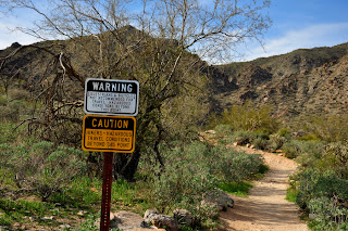
 The park has several areas you can access the Ford Canyon Trail from. I began my hike from area #9. Pick up a map from the entrance fee station on your way in and follow to the Ford Canyon Road which will lead you to the trail access parking area. The hike begins by heading east, away from the direction you need to go, it drops into a deep wash and then climbs back out where you begin to head west toward the hills in front of you. The first 1.5 miles is relatively flat and meanders through cholla and saguaro cactus. I hiked this trail the first part of March, the desert was green and wildflowers were just starting to come out. You will crest a small hill at about 1 mile in and then follow down the back side into a large wash area. Ford Canyon will be straight ahead of you. The trail is still easy going at this point. At 1.75 miles in you will come to a sign waring you of dangerous hiking ahead. In my opinion, if you are comfortable climbing hills on rocky terrain you will be fine or in other words if you hike Camelback, then you should have no problem with this section, as it is much easier to navigate. Just be careful with your footing, you don't want to twist an ankle.
 |
| First area of granite rock |
 |
| I turned around about 100 yards beyond this point |
Length: 5 miles out and back to sandy wash just above granite rock area
Elevation Gain: 600 feet
Difficulty: Easy for first 1.75 miles, then low scale moderate
Season: Fall through Spring
Hiking Time: I did this route in 2 hours
Info: $6.00 entrance fee
Directions: Take I-10 West. Exit on Cotton Lane (the 303 is under construction and will soon be the exit you will take) Follow Cotton lane north 8 miles. Turn Left on Olive, follow for 4 miles to the park entrance.


No comments:
Post a Comment